Friday, August 26, 2016

The "Canals And The Era Of Water Transportation: Part II - Lancaster's County's Boon" Story

It was an ordinary day.  Yesterday's story told of the canals that were built in Lancaster County in the 1800s.  Today I will take you on a visual journey along the canals that ran from the Chesapeake Bay north to the Juniata River.  This canal was hand dug, lined with hand-cut stone with the excavated "fill" thrown along the water's edge to produce a tow path.  A covered bridge connected Columbia, PA, about 20 miles to the west of Lancaster, on the east side of the Susquehanna River, to Wrightsville, PA, on the west side of the river.  
Columbia is located at the top of this sketch. The Pennsylvania
Railroad tracks are along the edge of the city, along the river.
Between the railroad tracks and the river is the canal. 
The Pennsyl- vania Canal was on the east side of the river while the Susque- hanna and Tidewater Canal was on the west side of the river.  A two-tiered towpath was constructed along the south side of the covered bridge that ran across the river for transporting canal boats from the Pennsylvania Canal across the river using teams of horses and mules walking on the towpath.  The canal boats would then link with the Susquehanna and Tidewater Canal for their journey to Baltimore or to the Chesapeake and Delaware Canal which opened in 1840.  The only problem faced by the canal boat operators was the winter ice and floods that closed the canals.  Eventually the weather problems as well as the increase in railroad routes led to the decline of the canals, causing the canal at Columbia to be closed in 1901. The following photos are from a variety of sources from in old books to old photos found Online.  It was another extraordinary day in the life of an ordinary guy.


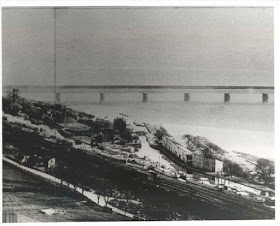
This view of the canal at Columbia is looking south toward the covered bridge.  The piers of the bridge in the background are still in the river.  You can see the lock and basins in the foreground.
The Susquehanna Canal parallels the Pennsylvania Railroad at the base of Chickies Rock near Columbia as seen on this 1908 postcard.  Note the new utility poles that are not yet wired.  Chickies Rock is a county landmark.  Near its summit was an amusement park which was accessible by trolley line from Columbia.  This scene is looking south along the Susquehanna.  
A postcard showing the canal basin.
Here you can see the many canal boats loaded with coal and the piles of coal that are between the canal and the Susquehanna River.
A photo from a book on the Pennsylvania Canal
A covered bridge over the canal in Columbia.
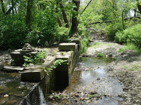
 So what remains?  Here are the remains of one of the outlet locks at Columbia, PA.  The land wall is looking towards the river.

No comments:

Post a Comment