Friday, September 22, 2017

The "The Mighty River Oyster: Part II - Commerce On/Over The River" Story

It was an ordinary day.  Visiting a new building in the city of Columbia, Pennsylvania called the Columbia Crossing River Trails Center.  
Columbia Crossing River Trails Center
Beautiful place that has photograph after photograph hanging from the walls of the center telling of the beginnings of commerce on the river which flows directly in front of the building.  Interesting story of the beginnings of commerce on the river are traced through photos dating back to the early 1800s when mills started to appear along the banks of the Susquehanna River.  
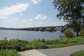
View of the Susquehanna River and bridge in Columbia.
Raw materials were needed to be sent south along the river for processing.  Cities such as Baltimore and Philadelphia were the cities that would receive the materials that could be transported by a variety of methods during the 1800s.  But, the lower Susquehanna was both rocky and shallow, making it both dangerous and extremely hard for transportation.  Arks and rafts were an early answer, but the danger involved led to other methods of transport.  Canals were the next method tried and I wrote a story a few years ago about the Eastern Division Canal on the upper Susquehanna to Columbia, PA and the Susquehanna-Tidewater Canal from Columbia to Havre de Grace.  Eventually bridges were built across the Susquehanna River and the transportation of raw material to the West began.  Follow along as I give you a visual journey showing the start of commerce on the Susquehanna River and the building of bridges over the river for commerce to the West.  The Susquehanna winds over 400 miles through three states, affecting the lives of thousands of people.  It is the longest non-navigable river in the United States and possesses great natural power.  The river has been crossed thousands of times by canoes, ferries, arks, rafts, horses, carriages, canal boats, locomotives and vehicles.  I'm sorry to say that my name is not one of those who have been brave, or should I say stupid, enough to attempt to cross it by walking/swimming across.  It was another extraordinary day in the life of an ordinary guy.


Rafts were a popular, but dangerous means of sending lumber down the Susquehanna.  Lumber rafts were lashed together into fleets of two.  Each fleet carried at least four crewmen: a pilot, two steerers and one more man, just in case.
Arks carried cargo such as milled lumber, charcoal and agricultural produce.  Arks, much like their predecessor, could withstand only one trip down the river.  The rafts could be up to ninety feet long and twenty feet wide and pointed at both ends.  The crew would steer using oars and poles to avoid sand bars, rocks and rapids.  In 1827 it was documented that 1,600 rafts and 1,300 arcs passed Harrisburg, PA that year on the Susquehanna.
In the late 1820s a canal was built on the Columbia side of the Susquehanna which brought materials from the north to Columbia.  
Early canal boats were primitive and provided few comforts for passengers.  A lock system, as seen here, was used to ferry boats across the river to switch canal systems, eventually taking the goods to Havre de Grace and the Chesapeake Bay.
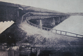
Bridges were a means of transporting goods across the river to either take them from one canal on the east shore of the river to the west shore for further transportation by canal, or for transportation to western Pennsylvania.  This was the first bridge built in 1814.  It was a covered wooden bridge that was 5,600 feet long on 53 stone piers.  Thick ice hardened in the winter of 1832 which came down the river and created an ice jam which caused flooding and lifted the bridge off the piers.
The second bridge was built from 1832-34 with the same length as the first bridge.  Along the outside of the bridge were two tow paths for moving canal boats.  They were added in 1840.  A double railroad track was added in 1850.  This was the bridge that was burned in June of 1863 to prevent Confederate troops from crossing the Susquehanna River on their way to Philadelphia.
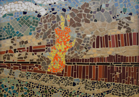
This is a stained glass representation of the burning of the bridge over the Susquehanna in 1863.
Another depiction showing the burning of the bridge.
The third bridge was also a covered wooden bridge with two Iron Truss Spans and was constructed in 1868-1869.  It was 5,390 feet long.  In September of 1896 Cedar Keys Hurricane hit Columbia and swept the bridge from its piers to the nearby town of Marietta, PA.
Another view of the wooden bridge.
The fourth bridge was constructed in 1896, less than a month after the other bridge was destroyed.  The plans called for two decks; one for rail traffic and one for all other traffic.  Didn't happen so when rail cars crossed the bridge, all other traffic stopped traveling between Lancaster and York, PA.  This bridge was dismantled in 1962.
This photo shows two cars next to one another on the bridge.  You can see the railroad tracks under them.
The fifth bridge was a reinforced concrete arch bridge built in June of 1929.  It cost $2,484,000 and was just south of the fourth bridge.  Tolls were charged for vehicles until 1943 when the construction debt was paid off.
Car that didn't make the correct turn.

This old postcard show the toll booths on the bridge on the Columbia side of the bridge.
This photo shows the bridge from the water.
Photo from 1976.

A postcard showing the tool booth on the York County side of the bridge.  The bridge became known as the Veterans Memorial Bridge and carried Interstate Route 30 from the east coast to the west coast.  
The following show different views from different seasons of the current bridge.


No comments:

Post a Comment